The Swiss Alps
I’m writing this on a train travelling from the city of Chur, in the (more or less) south-east, to Basel, in the (more or less) north-west. This is a 2 ½ hour trip, and ends 7 amazing days in the Swiss Alps.
Apart from
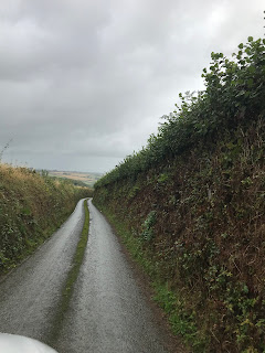
last night when we were near St. Moritz, we stayed with our friends Edith and
Sarah at their second home in a tiny village called Tschamut – see photo below.
It is near Andermatt, a major ski resort, and is reached from Andermatt by
crossing Oberalppass, ~ 2044 m a.s.l. Below Tschamut runs the Rhine River: well,
the main branch of the formative Rhine – there is a second branch which joins
this one at Reichenau-Tamins – more on that branch of the river later. For this
branch, there is an official site marking the source of the river (a high lake,
about 1 hr walk upstream and uphill) but we didn’t have the time or weather on
our side to visit it.
Tschamut

Major
visits:
·
Zermatt
and Gornergrat – to see the Matterhorn but it wasn’t on display that day –
shrouded in heavy cloud ….
·
Mortseratch
Glacier (we stayed last night in a hotel very close to the glacier valley)
·
Mouttas
Muragl – high above St. Moritz (2456 m a.s.l.)
·
Piz
(Mt.) Nair – even higher above St. Moritz (3056 m a.s.l.)
Some
selected photos below. They speak for themselves as to the grandeur and wonder
of the Swiss Alps. At Piz Nair we were literally surrounded 360o by
peaks ranging between 3000 m and 4000 m – the highest is Piz Bernina, at just
over 4000. Matterhorn is 4400 m, I think it’s the highest in Switzerland – but
I dunno, we didn’t see it!
The region
is highly commercialised of course (skiing, mountain biking, hiking, all sorts
of activities year-round in most resorts), populated with many small towns and
villages, crisscrossed by road and rail so the magnificent sites/sights are
readily accessible for locals and tourists. Think Fiordland-made-accessible and
developed with all of the above found in Switzerland and you get a sort-of
picture. It is not National Park country – in fact, Switzerland only has one
National Park. Of course, Fiordland is a protected NP, and its magnificent
sites/sights are only accessible via foot on the main tracks. So, very
different situation. The Swiss Alps region was like one big National Park to us,
in terms of scenery and rugged lansdcapes.
Glaciers, from Riffelsee on the Gornergrat railway, above Zermatt

Mortseratch glacier. Jen is standing at the point where the glacier snout was in c. 1880. It is another 3-4 km up-valley to the present snout.

View from Mouttas Muragl. St Moritz is in the valley floor, by the lake, almost dead centre of the photo. The 'drop' (symbolising water in it's most basic physical form) is one of several art installations scattered around the walking tracks above the rail terminus

View from Piz
Nair - well, one of the possible panoramas anyway! This one is looking across to the mountains above the Mortertsch glacier. Piz Bernina, the highest in these parts at just over 4000 m is pretty-much dead centre on the skyline.

Enjoying a beer on the terrace at Piz Nair 3056 m a.s.l. – sunny and warm (the weather,
not the beer)!

The
weather
Speaking of
weather … Like all alpine areas, the weather in these parts is changeable and
unpredictable. The locals describe the area as “the weather gods kitchen” –
something is always brewing. We had a fair bit of rain, some snow (at Tschamut,
but also during a couple of day trips), and (for the last 2 days) beautiful
clear sunny days. On one day, we drove with E&S to Lucarno, to the south,
partly to escape the rain! This is the Italian part of Switzerland (there is a
long, shared border between the two countries, mostly running along the
3000-4000 m mountain summits of the Swiss-Italian Alps). This day, the
temperature was ~ 16 degrees at Lucarno, but on the return trip to Tschamut it
dropped to zero as we went over Passo del Lucomango where it was snowing
heavily. Those two points are probably only 30-40 km apart in a direct line.
Getting around
The Alps area is pretty expansive – hard to judge just how
big, but I’d say at least Otago + Canterbury, maybe more. There is no such
thing as a direct line in the Swiss Alps, road or train-wise. But there are
gazillions of tunnels and bridges/viaducts, many of the latter quite
spectacular (Google the Landwasser viaduct to see a famous example which we
crossed twice in the last 2 days – but the train is the worst place to get a
view of the height and elegance of the structure!). There are also incredible
switchbacks, in the roads, but also the railway. The trains are amazing in
terms of where they go (altitude, terrain – often very steep country with
near-vertical drops to rivers below) and the power of them (all electric)
pulling uphill. We loved our train trips – there were about 15 discrete
journeys in-all during our week in the Alps, starting in Zurich and ending in
Basel hopefully – assuming this train gets to our destination! It will: the
trains run pretty much exactly and consistently to time, remarkable given the
terrain they are crossing, The Swiss have really got this nailed.
Winch railway at Mouttas Muragl

Then there are countless cable cars, funiculars (cog
railways) and straight-out winch-drawn carriages going off up steep slopes in
all directions. Not to mention the ski field chair lifts – more gazillions. They
take you to all parts of the mountains. They are not included in our Eurail
Pass (they are privately-run tourist services) and are expensive: e.g. SFr. 110
each to Gornergrat and return, that’s about $NZ190. But: hang the cost, the
experience is (almost literally) out of this world. We did not begrudge paying,
or hold back, while we had the chance.
Great excursions
Edith and Sarah were amazing local travel agents, they had a
bevvy of small-ish trips lined up that were suitable for the wet weather we had
for the first 4 days.
The
Rhine River(s)
One wet sort of day, we went by train from Ilanz to Reichenau-Tamina where the Vorderrhein (the ‘Front Rhine’ which runs below Tschamut) has carved out a mighty gorge of the river, with vast towering cliffs of granite. This is known as the Rheinschult, Rhine Gorge. Actually, we passed through it again later in our stay, en route to Mortseratsch.
The same day, E&S drove us south following the
Hinterrhein, the ‘Back Rhine’. This took us via Thusis to the amazing Viamala
Schlucht, a deep narrow chasm through the rocks forged by the river over ~
30,000 years (the time to deepen the gorge from the present-day entrance to the
steps to the present-day water level). It is very hard to get the enormity
(depth, and sheer vertical sides) of this gorge in pictures: the one below is
the best we could muster using our phones (hopefully there will be better
photos from the camera when we get to download them at the end of the trip).
Viamala Schult. Look closely to see the staircase going down below the building, and a viewing platform further down on the other side of the river Rhine, reached via a tunnel

Close nearby, in the village of Zillis, in which we paid a
quick visit to the church with its famous roof fresco.
The fortress in the mountain
I mentioned above the long border between Switzerland and
Italy. This hasn’t always been a good thing as far as the Swiss are concerned,
especially in WWII when Mussolini was intent on invading through Switzerland to
get deeper into the battlefield zones of central and western Europe.
Switzerland was, of course, neutral in WWII, but that doesn’t mean they didn’t
take measures to protect themselves.
One example of this is Sasso San Gotthardo, an amazing
cavernous defensive tunnel network built in a sheer rock mountain above the
Passo del Gotthard (Gotthard Pass, at > 2000 m a.s.l.) in 1931-1943 to house
Swiss military leaders in the event of an invasion. It also housed an armed
force with 15 cm canons pointing to the Passo San Giacomo linking Italy and
Switzerland, only ~ 20 km south. The military fort part of the complex was
built 1941-1945, and is accessed by ~ a 0.5 km (more?) straight tunnel and 475
steps up (or ride the cable car – as we did) to the canon placements. All-up,
there are 3 km of tunnels, plus numerous caverns housing accommodation,
communications centres, ammunition, a back-up oil-fired generator plant capable
of powering the whole she-bang if external power was cut) etc etc. A
medium-size fort, all underground and virtually invisible unless you know where
to look up the sheer rock face.
View above Passo del Gotthard from a platform reached via the fortress in the mountain. Enlarge the photo and focus on the very right-hand side, about mid-way between top and bottom – see barrel of canon poking out from curtain of chains

Soldiers were stationed here, in three-week tours of duty, which must have been pretty gruelling not seeing the sun for that time, a bit like being in a submarine. Apparently, there were several of these forts built into the Swiss mountains, all supposedly top-secret. Given there would have been ‘000s of people working on building them (an amazing feat), it’s hard to believe they were truly kept secret. This particular one was never used in anger against Mussolini. It was used by the Swiss military up until the late 1970’s (I think it was). The one remaining cannon that is still mounted was last fired in 1998.
Just because Switzerland has a strict policy of neutrality
when it comes to armed conflict doesn’t mean they aren’t tooled-up. Military
service was (not sure if it still is) compulsory for all Swiss males ages
18-24, 3 years-worth, plus follow-up 3-week refreshers thereafter. There is a
significant army and air force – but a substantial saving on kitting-out a
navy!
St. Moritz, Zermatt and Andermatt
These are all well-known and busy resort towns, in which we only spent a brief amount of time. From which we gleaned: St. Moritz is definitely for the very rich, with high-end fashion brands everywhere – more Ritz than St. Mo; Zermatt, more traditional Swiss architecture, also quite ‘ritzy’ but more under-stated that St. Moritz, more similar to Queenstown in its feel; Andermatt, I liked the most perhaps because it was the closest to our base at Tschamut!
Interestingly, there is a wealthy Egyptian businessman who
has taken a strong shine to Andermatt and the surrounding region and is
investing heavily in hotels, ski fields, golf courses etc etc. But with a nod
toward the local environment and people, so done with them in mind.
Next
We now have 2 nights in Basel, then 2 in Amsterdam before
joining Hugh and Anna (and Ellie) at Thierry and Jane’s (Anna’s parents) at Wimmille,
near Boulogne in northern France.
After which it is back to London for one night before catching
our flight to Melbourne, and the end of our marvellous 10 weeks in Great Britain
and Europe. It’s been a blast!


Comments
Post a Comment